The Oil and Gas industry is turning to the cloud for its digital transformation. In the race to revolutionize E&P, companies are faced with a chicken-and-egg problem:
- How to build cloud-based applications when the data is still within the confines of the company network?
- Why move to the cloud when there are no applications that are able to use this data?
INT has been a long-time pioneer by providing JavaScript components that empower developers to build geoscience applications that run in a browser. The GeoToolkit.JS libraries cut years of development time for any company creating a new application or replacing a legacy system. However, the added value of this kind of application is not just in accessing and visualizing geoscience data, it’s also in the integration of the company’s knowledge within this application.
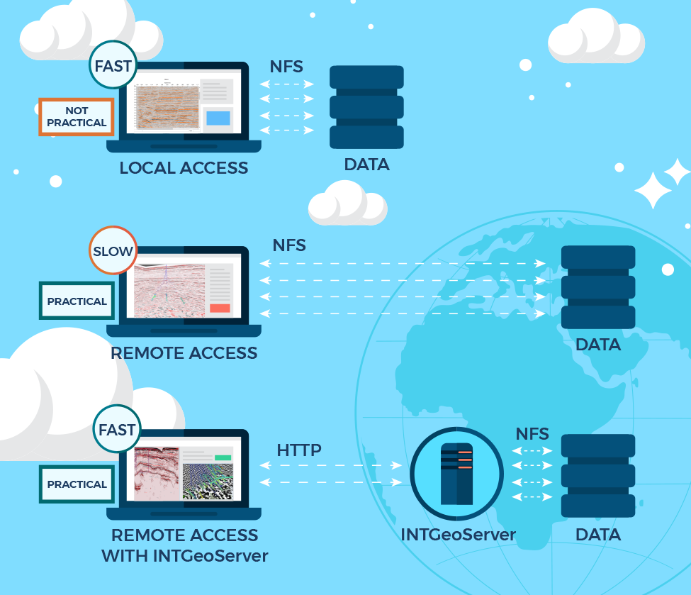
While GeoToolkit.JS provides the tools to visualize geoscience data, INTGeoServer provides the tools to access remote data. This server has been designed to serve seismic and well data efficiently to web clients. It uses the HTTP protocol and works natively with your existing files (such as SEG-Y, SEP, and LAS). In just a few clicks, you can have a running instance of INTGeoServer, upload files to the cloud, and visualize them immediately with GeoToolkit.JS.
Most customers using INTGeoServer elect to install several instances. To work efficiently with seismic data, INTGeoServer needs to be close to that data. Since E&P companies have their data scattered all over the globe, so are the installations of INTGeoServer, allowing access to datasets from multiple sources in one application. In a classic configuration, data ubiquity is typically achieved by deploying worldwide file systems. INTGeoServer optimizes remote data access by applying several techniques that networks cannot use: only sending the data that the GeoToolkit.JS client needs through the network, limiting the round trips, and compressing the data leveraging similarities between adjacent traces.

GeoToolkit.JS has a built-in API to access INTGeoServer instances. It only takes a few lines of code to program a JavaScript application that will read remote data and visualize it. As a result, programmers are free to focus on the added value of their application.
INTGeoServer also offers a nice transition from classic file systems to cloud-based storage. From the perspective of the web client, the code is storage-agnostic. While a company works on migrating its data to the cloud, its developers can use instances of INTGeoServer that are bound to the company network. Once the cloud is ready, no changes to the application are required. You do not need to decide in advance which cloud provider will host your data. INTGeoServer works with Amazon S3, Microsoft Azure Blob Storage, and Google Cloud Storage. If your application serves data from multiple vendors, you can let each vendor choose their own cloud.
GeoToolkit.JS is meant to empower developers. It provides ready-to-use components that can be customized by developers outside of INT. Similarly, INTGeoServer is a platform. It has an API allowing you to add your own data formats, your own security, and your own science. As the audience of your application grows, you might elect to implement your own data server. INTGeoServer facilitates this future transition by documenting the HTTP protocol it implements. You are free to implement your own version of this protocol, keeping your JavaScript web application running without requiring any changes. In this particular scenario, INTGeoServer gives you a definitive time-to-market advantage.
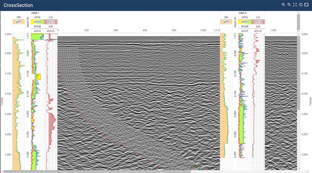
GeoToolkit.JS allows requesting seismic data, log curves, trajectories and horizons form INTGeoServer. The following screenshot displays a cross-section display built with data located on INTGeoServer.
LogCurve can be requested using a simple REST API from INTGeoServer and visualized inside WellLogWidget or MultiWellWidget.
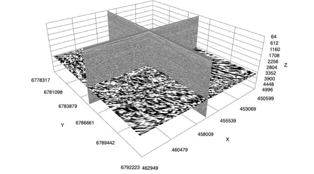
Seismic data in different formats like SEG-Y, SEG-D, SU, and others can be indexed by a utility provided with INTGeoServer, and GeoToolkit.JS can leverage it using sophisticated queries. It is easy to request seismic sections using RemoteSeismicDataSource and specify an arbitrary path or INLINE and XLINE to get data located in cloud or private storage. Moreover, the seismic volume can be visualized in 3D with the Carnac3D module of GeoToolkit.JS.
As the industry continues to shift towards a digital transformation, more and more E&P companies will migrate their data to the cloud. And with the support of GeoToolkit.JS and INTGeoServer, it becomes simple and efficient to integrate, access, and visualize a company’s data within an application in the cloud.
For more information about GeoToolkit and INTGeoServer, visit the GeoToolkit product page or contact us for a free trial.


