
Jumpstart the Development of Your Next Cloud Application with GeoToolkit.JS and INTGeoServer
INT has been a long-time pioneer by providing JavaScript components that empower developers to build geoscience applications that run in a browser. The GeoToolkit.JS libraries cut years of development time for any company creating a new application or replacing a legacy system. However, the added value of this kind of application is not just in accessing and visualizing geoscience data, it’s also in the integration of the company’s knowledge within this application.
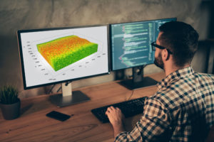
Optimizing 3D Subsurface Web Applications with GeoToolkit
Despite the advantages of 3D rendering and the trend of migrating applications to web browsers, there are various obstacles that developers have to face and overcome. The steep learning curve, the insufficient cross-platform support, and the difficulty of maintaining make WebGL a beast to work with. In a way, we want to keep the obstacles away from web developers, so INT provides Carnac3D, a subset of GeoToolkit, as an industry-leading graphical product.

INT Brings OpenVDS Java Binding to the OSDU Community
Recently, INT announced our partnership with Bluware and our integration of Bluware’s OpenVDS format into IVAAP, our enterprise data visualization platform. We are very excited about this partnership, as well as our collaboration with OSDU. This new format was designed to empower users to browse seismic data in the cloud with high performance and lower cost.
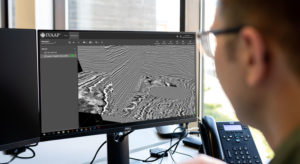
INT Releases Latest IVAAP Version Supporting OSDU Release 2
IVAAP on OSDU R2 supports seismic visualization, data aggregation with unparalleled performance in the cloud to serve large seismic volumes using IVAAP’s HTML5 technology combined with OpenVDS format.